Map - Mamucium (Manchester)

Mamucium (Manchester)
Mamucium, also known as Mancunium, is a former Roman fort in the Castlefield area of Manchester in North West England. The castrum, which was founded c. AD 79 within the Roman province of Roman Britain, was garrisoned by a cohort of Roman auxiliaries near two major Roman roads running through the area. Several sizeable civilian settlements (or vicus) containing soldiers' families, merchants and industry developed outside the fort. The area is a protected Scheduled Ancient Monument.

The ruins were left undisturbed until Manchester expanded rapidly during the Industrial Revolution in the late 18th century. Most of the fort was levelled to make way for new developments such as the construction of the Rochdale Canal and the Great Northern Railway. The site is now part of the Castlefield Urban Heritage Park that includes renovated warehouses. A section of the fort's wall along with its gatehouse, granaries, and other ancillary buildings from the vicus have been reconstructed and are open to the public.

Mamucium is generally thought to represent a Latinisation of an original Brittonic name, either from mamm- ("breast", in reference to a "breast-like hill") or from mamma ("mother", in reference to a local river goddess). Both meanings are preserved in modern Celtic languages, mam meaning "mother" in Welsh. The neuter suffix -ium is used in Latin placenames, particularly those representing Common Brittonic -ion (a genitive suffix denoting "place or city of ~"). The Welsh name for Manchester is Manceinion.It should be stressed that the ancient name is unknown. Roman authorities give both Mancunium and Mamucium, but it is not clear that either form is correct.

 
Map - Mamucium (Manchester)
Map
Google Earth - Map - Mamucium
Google Earth
Openstreetmap - Map - Mamucium
Openstreetmap
Greater_Manchester_C...
3358x2443
upload.wikimedia.org
iscron.jpg
2865x2677
personalpages.manche...
Manchester-Map.jpg
1890x3166
mappery.com
Manchester-Map.jpg
1890x3166
www.mappery.com
Manchester_City_Regi...
2766x2053
upload.wikimedia.org
Soviet_Military_Map_...
2664x1968
personalpages.manche...
Trafford%20Centre%20...
2209x2356
www.projectmapping.c...
manchester-attractio...
2105x1488
cdn-locations.tripom...
centralmanchester.jp...
1541x1720
citiesmcr.files.word...
carpark_map.GIF
1516x1116
www.actuaries.org
University-of-Manche...
1441x948
www.mappery.com
Manchester-Map-2.jpg
1449x844
mappery.com
Manchester-Map-2.jpg
1449x844
www.mappery.com
Mapa-Topografico-de-...
1183x988
mapas.owje.com
Map_of_Manchester_18...
1059x919
upload.wikimedia.org
779_thumbnail-1024.j...
1023x898
www.mobilemaplets.co...
Manchester-2012.png
648x1043
www.tundria.com
postcodes-large.jpg
800x577
www.mancky.co.uk
manchestermap.jpg
720x540
2.bp.blogspot.com
Manchester-Map.jpg
520x672
www.christmastreesma...
Country - United_Kingdom
Flag of the United Kingdom
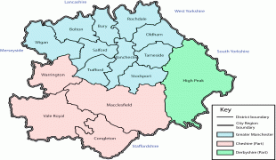
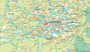
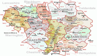
The United Kingdom of Great Britain and Northern Ireland, commonly known as the United Kingdom (UK) or Britain, is a country in Europe, off the north-western coast of the continental mainland. It comprises England, Scotland, Wales and Northern Ireland. The United Kingdom includes the island of Great Britain, the north-eastern part of the island of Ireland, and many smaller islands within the British Isles. Northern Ireland shares a land border with the Republic of Ireland; otherwise, the United Kingdom is surrounded by the Atlantic Ocean, the North Sea, the English Channel, the Celtic Sea and the Irish Sea. The total area of the United Kingdom is 242,495 km2, with an estimated 2020 population of more than 67 million people.

The United Kingdom has evolved from a series of annexations, unions and separations of constituent countries over several hundred years. The Treaty of Union between the Kingdom of England (which included Wales, annexed in 1542) and the Kingdom of Scotland in 1707 formed the Kingdom of Great Britain. Its union in 1801 with the Kingdom of Ireland created the United Kingdom of Great Britain and Ireland. Most of Ireland seceded from the UK in 1922, leaving the present United Kingdom of Great Britain and Northern Ireland, which formally adopted that name in 1927. The nearby Isle of Man, Guernsey and Jersey are not part of the UK, being Crown Dependencies with the British Government responsible for defence and international representation. There are also 14 British Overseas Territories, the last remnants of the British Empire which, at its height in the 1920s, encompassed almost a quarter of the world's landmass and a third of the world's population, and was the largest empire in history. British influence can be observed in the language, culture and the legal and political systems of many of its former colonies.
Currency / Language  
ISO Currency Symbol Significant figures
GBP Pound sterling £ 2
Neighbourhood - Country  
  •  Ireland